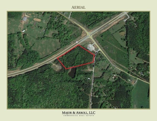
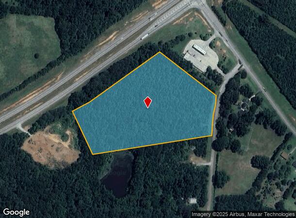
Property Record
1036 Mangham Rd, Griffin, GA 30224
NEARBY LISTINGS FOR SALE OR LEASE
Property Detail
1036 Mangham Rd
218-02-024
1036 MANGHAM RD TR B 24/762
Agriculturalland
Spalding
X
Georgia
13255C0210E
10.21 AC
2024
Spalding County
2024
Atlanta
161000
Atlanta-Sandy Springs-Roswell, GA
DEMOGRAPHICS near 1036 Mangham Rd
1 Mile
3 Mile
5 Mile
2024 Total Population
611
4,442
17,193
2029 Population
644
4,691
18,338
Pop Growth 2024-2029
+ 5.40%
+ 5.61%
+ 6.66%
Average Age
41
41
40
2024 Total Households
231
1,662
6,442
HH Growth 2024-2029
+ 5.19%
+ 5.48%
+ 6.60%
Median Household Inc
$48,958
$63,638
$64,070
Avg Household Size
2.60
2.60
2.60
2024 Avg HH Vehicles
2.00
2.00
2.00
Median Home Value
$158,080
$179,854
$186,244
Median Year Built
1985
1987
1986
Nearby Places
Map Layers
Map Styles
 Street
 Aerial
- Restaurants
- Banks
- Shops
- Fitness
- Groceries
SALE & LEASE HISTORY
LISTING DATE
SALE/LEASE

Oct 24, 2019
For Sale
Nearby Properties
Address
Land Use
TOTAL SIZE
Lot Size
Zoning
Address
Land Use
TOTAL SIZE
Lot Size
Zoning
303,594 SF
58.69 AC
PDD
Address
Land Use
TOTAL SIZE
Lot Size
Zoning
13,392 SF
31.70 AC
Address
Land Use
TOTAL SIZE
Lot Size
Zoning
39,105 SF
33.98 AC
PDD
Address
Land Use
TOTAL SIZE
Lot Size
Zoning
48,856 SF
35.46 AC
PDD
Address
Land Use
TOTAL SIZE
Lot Size
Zoning
72,876 SF
16.23 AC
PDD
Address
Land Use
TOTAL SIZE
Lot Size
Zoning
39,105 SF
33.98 AC
PDD
Address
Land Use
TOTAL SIZE
Lot Size
Zoning
48,856 SF
33.47 AC
PDD
Address
Land Use
TOTAL SIZE
Lot Size
Zoning
62,748 SF
22 AC
PDD
Address
Land Use
TOTAL SIZE
Lot Size
Zoning
303,594 SF
58.69 AC
PDD
Address
Land Use
TOTAL SIZE
Lot Size
Zoning
72,816 SF
16.23 AC
PDD
Address
Land Use
TOTAL SIZE
Lot Size
Zoning
70 SF
281.50 AC
PDD
Address
Land Use
TOTAL SIZE
Lot Size
Zoning
7,686 SF
2 AC
C-1
Address
Land Use
TOTAL SIZE
Lot Size
Zoning
Address
Land Use
TOTAL SIZE
Lot Size
Zoning
290.41 AC
AR1/R2
Address
Land Use
TOTAL SIZE
Lot Size
Zoning
178.20 AC
Address
Land Use
TOTAL SIZE
Lot Size
Zoning
203.23 AC
Address
Land Use
TOTAL SIZE
Lot Size
Zoning
62,748 SF
22 AC
PDD
Address
Land Use
TOTAL SIZE
Lot Size
Zoning
206.93 AC
Address
Land Use
TOTAL SIZE
Lot Size
Zoning
9,800 SF
10 AC
Address
Land Use
TOTAL SIZE
Lot Size
Zoning
186.29 AC
Address
Land Use
TOTAL SIZE
Lot Size
Zoning
25.29 AC
Address
Land Use
TOTAL SIZE
Lot Size
Zoning
Address
Land Use
TOTAL SIZE
Lot Size
Zoning
96.72 AC
AR1
Address
Land Use
TOTAL SIZE
Lot Size
Zoning
127.45 AC
Address
Land Use
TOTAL SIZE
Lot Size
Zoning
207.06 AC
AR
Address
Land Use
TOTAL SIZE
Lot Size
Zoning
100.53 AC
Address
Land Use
TOTAL SIZE
Lot Size
Zoning
108.31 AC
AR1
Address
Land Use
TOTAL SIZE
Lot Size
Zoning
7,500 SF
10 AC
Address
Land Use
TOTAL SIZE
Lot Size
Zoning
94.87 AC
R2
Address
Land Use
TOTAL SIZE
Lot Size
Zoning
141.88 AC
AR
The World's #1 Commercial Real Estate Marketplace
Connect with us
© 2025 CoStar Group
The information above has been obtained from sources believed reliable. While we do not doubt its accuracy we have not verified it and make no guarantee, warranty or representation about it. It is your responsibility to independently confirm its accuracy and completeness. Any projections, opinions, assumptions, or estimates used are for example only and do not represent the current or future performance of the property. The value of this transaction to you depends on tax and other factors which should be evaluated by your tax, financial, and legal advisors. You and your advisors should conduct a careful, independent investigation of the property to determine to your satisfaction the suitability of the property for your needs.